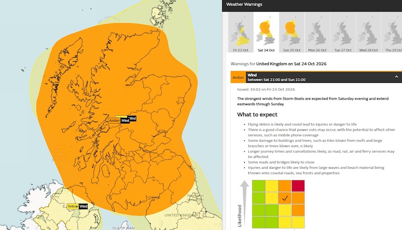
The Highlands and Islands are bracing for a weekend of severe weather as Storm Boelo approaches Scotland, bringing winds of up to 80mph and warnings of potentially dangerous conditions.
The Met Office issued an amber weather warning on Friday 23 October covering the Highlands, Western Isles, Moray and much of mainland Scotland, with the worst conditions expected from Saturday evening through Sunday.
Forecasters are predicting widespread gusts of 60 to 70mph, potentially reaching 80mph in exposed coastal locations.
The amber warning begins at 9pm on Saturday 24 October and remains in force until Sunday evening, while a wider yellow warning takes effect from midday on Saturday.
Orkney is also included in the yellow warning area, with strong winds expected across northern Scotland throughout the weekend.
The strongest winds will initially affect western Scotland before spreading eastwards overnight and during Sunday, accompanied by heavy rain and frequent showers.
The Met Office warns that flying debris could pose a danger to life, with damage to buildings, fallen trees and widespread disruption to transport all possible.
Roads and bridges could be forced to close, while rail services, flights and ferries face delays or cancellations.
Power cuts are another significant concern, particularly in rural communities where interruptions to electricity supplies can also affect mobile phone coverage.
Coastal areas face additional dangers from large waves, with sea spray and beach material potentially being thrown onto roads, seafronts and properties.
Moray Council has issued its own warning, highlighting the risks posed by strong winds and heavy rainfall across the area.
Surface water flooding is a particular concern around Keith, Dufftown and Aberlour, where blocked drains and heavy rain could lead to localised flooding.
Council officials are also monitoring conditions around Kingston, where rising river levels, high spring tides and further rainfall could increase the risk.
By Sunday, attention is expected to turn towards coastal flooding as large waves, spring tides and a possible tidal surge combine.
Residents are being urged to secure garden furniture, bins, trampolines and other loose outdoor items before the strongest winds arrive.
Drivers should take particular care on exposed routes, while anyone planning to travel by ferry, rail or air is advised to check for service updates before setting out.
CalMac has already warned that adverse conditions could affect ferry services across its west coast network, with delays and cancellations possible.
People living in areas vulnerable to power cuts are encouraged to prepare torches, batteries and other essential supplies.
The public is also being advised to stay away from exposed coastlines, harbour walls and cliff edges, where large waves could make conditions particularly dangerous.
Anyone encountering fallen or damaged trees should keep clear and report them rather than attempting to remove debris themselves.
The latest warnings follow Storm Austen, which brought severe weather to other parts of Britain before moving away on Friday.
Met Office forecasters expect Storm Boelo’s winds to gradually ease from the west during Sunday, although unsettled weather could continue into next week.
With the strongest conditions expected overnight and across Sunday, residents throughout the Highlands and Islands are being encouraged to make preparations now and keep checking official forecasts as the storm approaches.